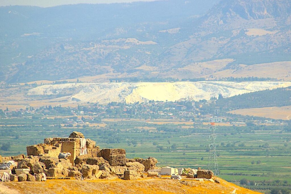
Laodicea is situated on a high plateau between fertile valleys surrounded and irrigated by the waters of Asopus (Gümüşçay) and Kapros (Başlıçay) streams. They are the tributaries of the Lycus River, known today as Çürüksu Çayı, flow on the north-eastern side of the hill.
Location: Goncalı, 20180 Pamukkale/Denizli. 6km north of Denizli, 12km south of Pamukkale and 325km east of Çeşme.
Laodicea Ancient City – Table of Contents
Brief History of Laodecia
At the crossroads of important trade routes, Laodicea on the Lycus was once a prosperous city famous for its black wool, banking services, and medical achievements. Important trade routes lead to the city from Sardis through Tripolis and Philadelphia; across the valley is the famous Roman spa of Hierapolis and Colossae, known from the Epistle to the Colossians written by St. Paul, which is 15 km to the east. It had a sizeable Jewish community and a significant congregation of Christians in late antiquity. St. John mentioned Laodicea as one of the Seven Churches in the Book of Revelation.
The oldest traces of human activity in the area can be dated to the Early Bronze Age period (3500 to 3000 B.C.). Coins and artefacts show the settlement had already existed in this location before the city’s foundation in the Hellenistic period; the settlement was initially called Dispolis (the City of Zeus) and then Rhodas. Laodicea was founded in the mid-3rd century B.C. by Antiochus II Theos (286 – 246 B.C.), the ruler of the Seleucid dynasty, to honour his wife, Laodice. He gave the name Laodicea to many other cities.
Antiochus III the Great (223 – 187 B.C.) brought 2,000 Jewish families from Babylon to the area, giving Laodicea a significant Jewish community and the basis later of an early Christian community. In 188 B.C., the Battle of Magnesia was lost to the Roman troops and at the Treaty of Apamea, western Asia Minor succeeded to the Kingdom of Pergamon. Later, its territory was given over to Rome.
The golden era of Laodicea’s prosperity was between the 1st and the 5th centuries A.D., through trade in textiles and the famous black wool of Laodicea, marble, cattle, and grain. Laodicea was a leading centre of medicine and a medical school, and ophthalmologist Demosthenes Philalethes work in the early 1st century A.D., “Ophthalmicus”, on diseases of the eyes, was still being discussed in the Middle Ages.
Earthquakes repeatedly destroyed the city, the most powerful of which struck in 27 B.C., and in 60 A.D., another wrecked Laodicea. Emperor Nero (37 – 68 A.D.) offered financial assistance in the reconstruction, but the citizens of Laodicea rejected the offer and paid their own money; their wealth through trade and banking was widely known in the ancient world. Roman Emperor Hadrian (76 – 138 A.D.) visited Laodicea in the summer of 129 B.C on the way from Greece to Cappadocia, Cilicia, and Syria.
Despite historians noting that the city was abandoned after another earthquake during the reign of Emperor Phocas circa 602 – 610 A.D., Byzantine writers mentioned Laodicea during the reign of the Komnenos dynasty in the 11th and 12th centuries and that in 1094 A.D., the city was conquered by the Seljuk army and recaptured in 1119 A.D. The city was repeatedly plundered during the late Byzantine Empire by the Turks and the Mongols, and the last inhabitants left it in the 13th century A.D.
Laodicea Ancient City
The Agoras (Market Places)
The Central Agora is located on the south side of Syria Street, a rectangular area of 112 x 60 metres, surrounded on three sides with porticos rising on a 2-step platform. To the south of the south portico is the wall of the Central Baths. Behind the east and west porticos are the doorways to the shops; the roof of the porticos would have been placed on the walls of the shops.
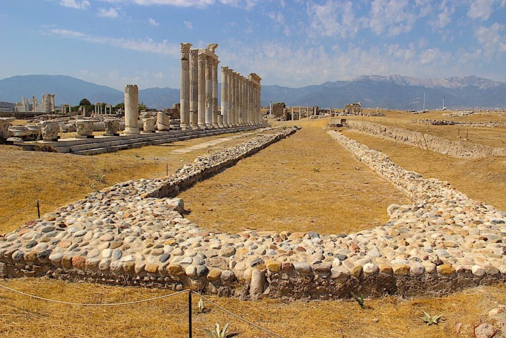
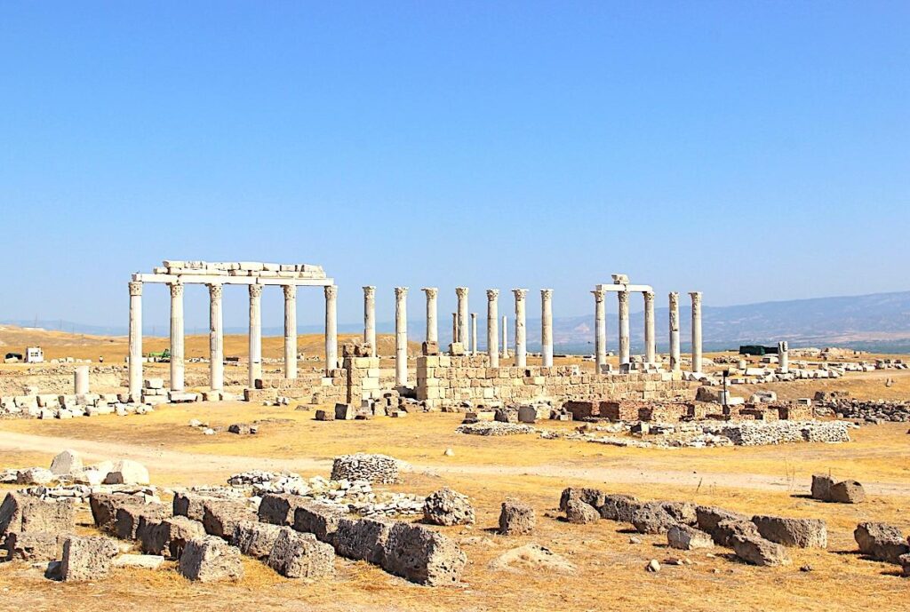
The Propylon I gate led into the North Agora, also known as the Sacred Agora. On the grounds of this substantial 35,000 square metre space were discovered the three temples dedicated to Athena, Zeus, and an unidentified deity. Renovation works in the agora have resurrected the colonnades that once surrounded the square. The back of the agora was bounded by an 11-metre high wall, 100-metre long, covered with paintings.
On the north side of the South Baths, adjacent to the Bouleuterion, was the State Agora, now called the South Agora, with dimensions of 135 x 90 metres. As with the South Baths, it was dedicated to Emperor Hadrian and his wife Sabina on their visit to Laodicea in 135 A.D.
Bouleuterion
The Bouleuterion (Council House), dating from the reign of Emperor Hadrian (76 – 138 A.D. Emporer 117 – 138 A.D.), was the place of town council meetings that could accommodate 500-600 people. The building probably also served as a small theatre for musical performances.
Sacred Area Porticos
The Sacred Area Porticos is a monumental structure on a three-level crepidoma south of the North Church. Attic-Ion plates, pillars, Corinth heads, architraves, frescos and geison-sima were used in the structure. There must have been temples and altars in the sacred area, which measures 250 metres by 100 metres. The structures fell in a northeast direction due to the earthquake. Excavations of the landfill in the area consisted of boulders, bricks, roof tiles, and ceramic pieces. The red pieces of ceramic were used in daily dishes and religious festivals. Thus, the structure was used for daily needs as well as its religious use.
Bath Houses
On the north side of Syria Street are the remains of the Eastern Bath on a higher elevation, dated to the Roman period 2nd century A.D. The building has a central layout with piers, arches, and vaults. It comprises an apodyterium (changing room), a frigidarium (cold room), a tepidarium (lukewarm room), and a caldarium (hot room). The level area extending west of the structure may be an agora.
The Central Baths are located on the south side of Central Agora, occupying an area of 89 x 58 meters, and were constructed in the 2nd century A.D. The bath complex, designed with a cascaded twin bath unusual to the region, comprised a caldarium (hot room), a tepidarium (warm room), two frigidaria (cold room), and two apodyterium (changing rooms). A palaestra (exercise area) and a triple-arched entranceway were on the west side of the baths. The baths were damaged by the earthquake in 494 A.D, and the building was used for other purposes until the early 7th century A.D.
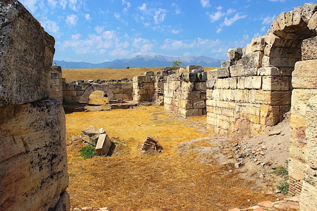
The South Baths complex stands on the northern side of the stadium with dimensions of 133 x 75 metres. The complex combines the role of baths and a gymnasium and was dedicated to Emperor Hadrian and his wife Sabina on the occasion of their visit to Laodicea in 135 A.D. The building served competitors practising in the adjoining stadium.
Gates at Laodecia
Just to the South of the modern entrance to the site lie the remains of the Syria Gate. The gate had three archways built with cut travertine blocks. It was constructed in the Doric order in 84 – 85 A.D., during the reign of Emperor Domitian (51 – 96 A.D. Emporer 81 – 96 A.D.).
Near the current entrance, the East Byzantine Gate, built at the end of the 4th century A.D., leads visitors to the centre of Laodicea. Emperor Theodosius I the Great and his son Arcadius constructed the new defensive walls surrounding the city, which had reduced in size compared to the previous period of prosperity. The gate is flanked by square-shaped towers projecting out from the walls and has two passageways, one for pedestrians and the other for horse carriages.
The monumental gate, Propylon I, stands on Syria Street, opposite the western corner of the Central Agora. It was built at the end of the reign of Emperor Septimius Severus (145 -211 A.D. Emporer 193 – 211 A.D.) and destroyed by an earthquake in the late 3rd / early 4th century A.D. and then rebuilt before collapsing completely during the earthquake of 494 A.D.
On the city’s western side is a ruined gate, known as Ephesian Gate, built at the end of the 1st century A.D. and dedicated to Emperor Domitian (51 – 96 A.D. Emporer 81 – 96 A.D.). It was a triple arch with watchtowers on both sides. Ephesian Street led through the gate westward along the Meander River valley to Ephesus. Near the Ephesian Gate, this road crossed the Asopus River on a partially preserved bridge known as the Roman Bridge on Asopus.
Theatres
On the north side of Laodicea are two ancient theatres. The older and smaller of them is the West Theatre, built in the Hellenistic period. It is oriented to a northwest axis, looking towards the white terraces of Pamukkale. The stage structure is raised to 6-7 metres, and the cavea is divided into 9 sections with 7 stairways. Up to 8,000 spectators were protected from the sun by an awning mounted on wooden poles; the holes where these poles were attached are visible today.
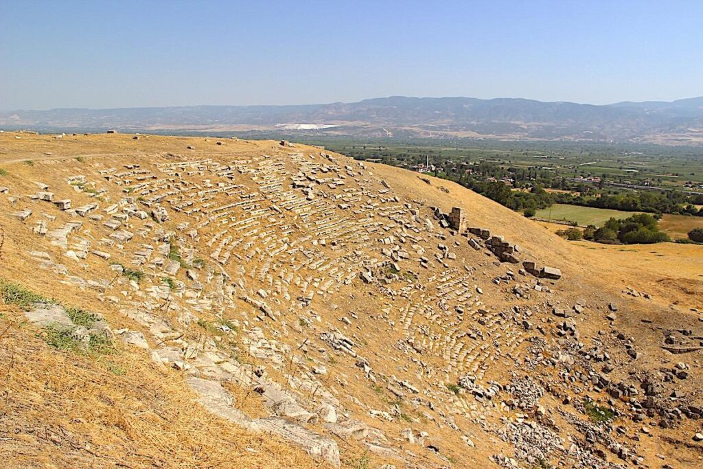
When the West Theater became too small for the growing city’s needs, the North Theatre, made of marble, was constructed. Built entirely into the hillside in the Greek manner, it faces in a north-easterly direction towards the valley of the Lycus River. There are 19 rows of seats in the lower section and 27 rows in the upper section visible today. The names of civic associations and leading families of Laodicea were engraved on the seats, marking the places reserved for them. It is estimated that the North Theatre could seat around 12,000 people. The theatre organised various shows up to the 7th century A.D.
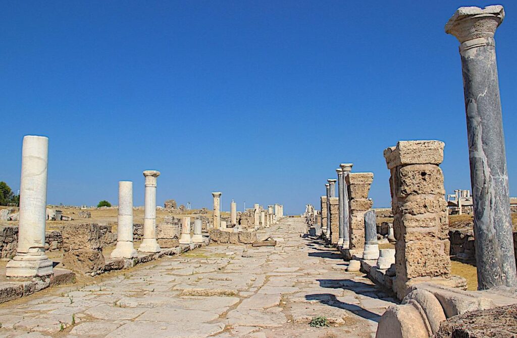
Syria Street
Syria Street is the 900-metre-long main thoroughfare stretching from the city centre to the Syria gate in the east. Excavations made clear the construction phases related to the earthquake of 494 A.D. and until the city’s abandonment. Sewage canals run underneath the middle of the street, flanked by colonnades rising on a single or two-step platform with shops behind. The section of the street extending from the East Byzantine Gate to the Caracalla fountain on the west is flanked by House A, Temple A, Fountain A, Propylon I, and shops on the north side and with shops and the Central Agora on the South side.
Stadium Street
Stadium Street crosses Syria Street in an east-west direction. There are porticos and rows of shops on both sides of the street. Opus sectile pavements are preserved in some porticos. The street changed continuously from the 2nd century A.D. to the city’s abandonment in the first half of the 7th century A.D. Stadium Street joins the West Theatre, the Stadium, the South Bath & Gymnasium, and Ephesus Portico. Some parts of the street that led to the West Theatre closed in the 5th and 6th centuries A.D. the connection with Syria Street was cut.
Nymphaeum (Fountains)
The remains of the East Byzantine Nymphaeum adjoin the north side of the East Byzantine Gate. This fountain was erected on a rectangular plan with 21.5 x 9.9 meters dimensions on the exterior and 18.7 x 6.8 metres on the interior. Its construction dates back to the 5th century AD., and bricks and stones obtained from the riverbed were used as the building materials. The main water tank, sealed with mortar, had a depth of 2.2 metres and supplied drinking water to people outside the city walls and the travellers arriving at Laodicea from the east.
The monumental fountain Caracalla Nymphaeum is located at the junction of Syria Street and Stadium Street, leading south. Thanks to its location on the corner, it has two facades and an unusual layout. Built honouring and dedicated to Emperor Caracalla (198 -217 A.D. Emporer 193 – 211 A.D.) on the occasion of his visit to Laodicea, the ancient structure is among the most significant structures of its time.
On the western side of Temple A, north of Syria Street, stands the Fountain of Septimius Severus, aka Nymphaeum A, erected from travertine blocks during the reign of Emperor Septimius Severus and dedicated to him. Like many other buildings in Laodicea, it was destroyed in the earthquake in 494 A.D. In the Byzantine period, two small rectangular pools were built before its parapet, and it consisted of a rectangular pool, surrounded on three sides by two-storey façades whose lower levels were adorned with columns. The pool was filled with water flowing from five taps. On the east and west sides of the building, facing Syria Street, were statues of lions. The spaces between the columns were decorated with statues of the deities of the Greek pantheon, including goddesses Athena and Tyche.
Churches & Temples
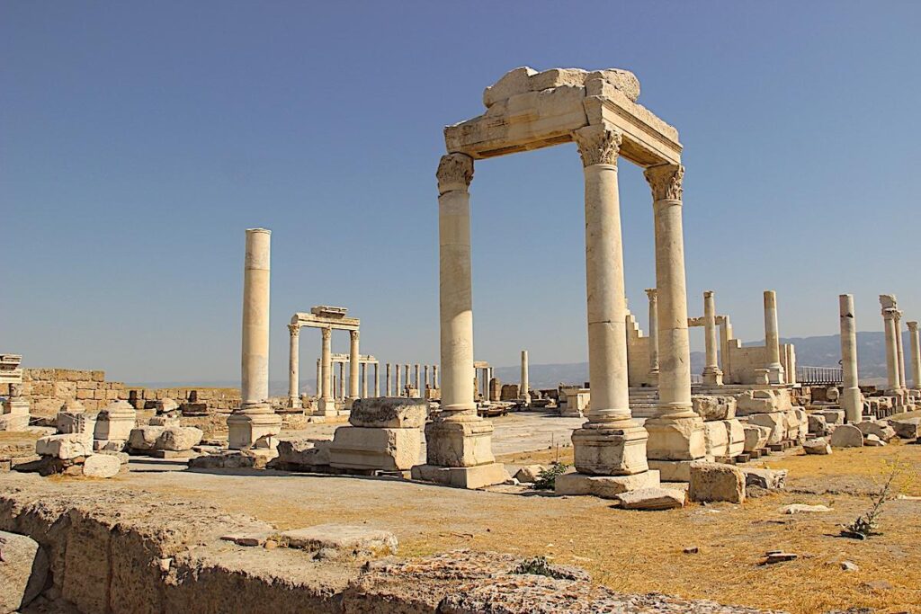
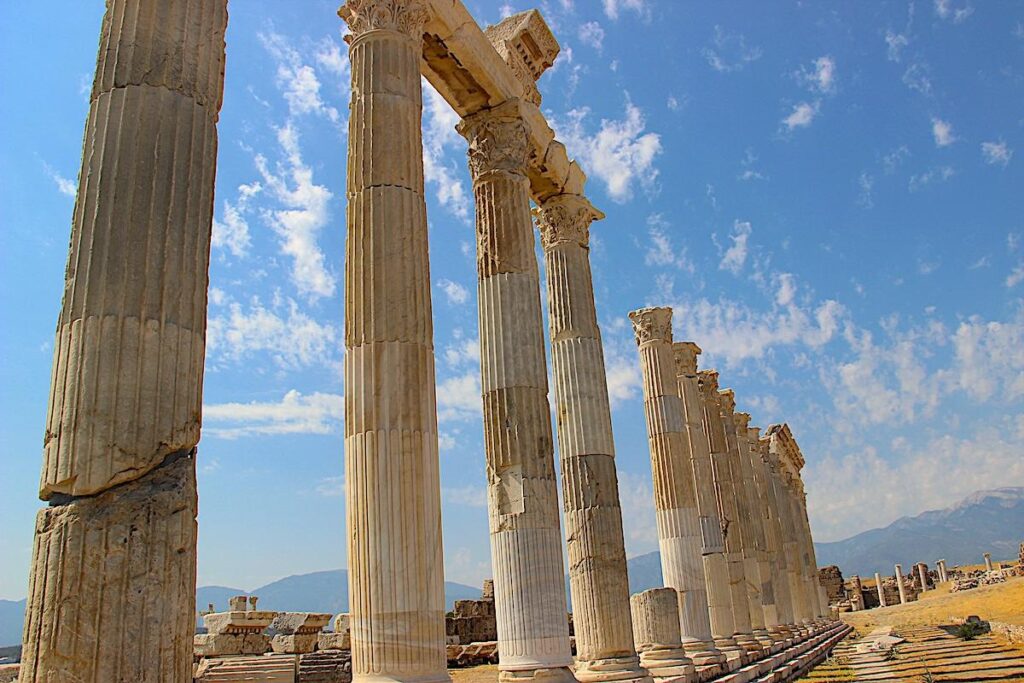
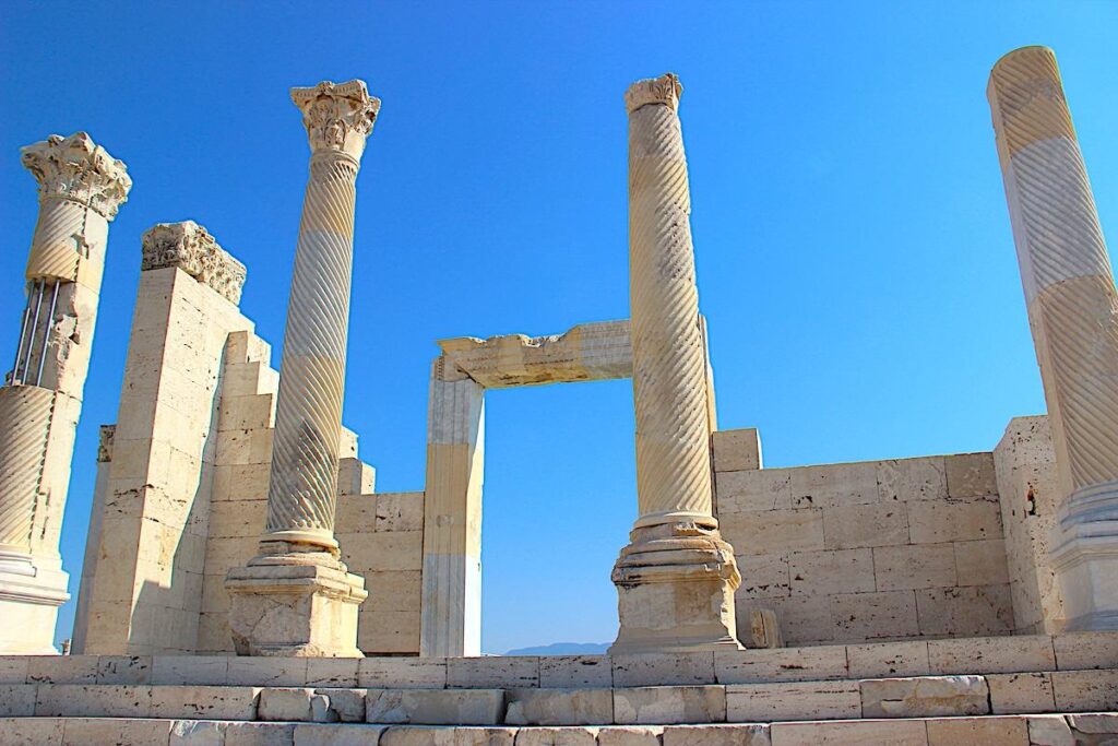
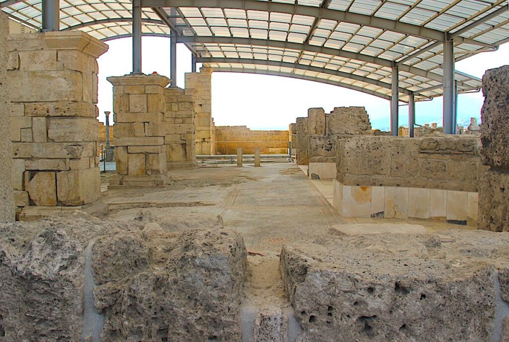
Constructed with travertine blocks on a high podium in the 2nd century A.D., Temple A on the north side of Syria Street was renovated in the reign of Emperor Diocletian (245 -312 A.D. Emporer 284 – 305 A.D.). When Christianity was accepted in the city, it served as an archive of the Laodicean Church. The temple has four spirally fluted columns in the front and measures 27.8 x 13.6 metres. It was destroyed by an earthquake in 494 A.D. It was partially restored, with a steel structure and glass floor that provides a view of the sacred room, carved columns and the foundations supporting the temple. 19 columns have been restored and raised.
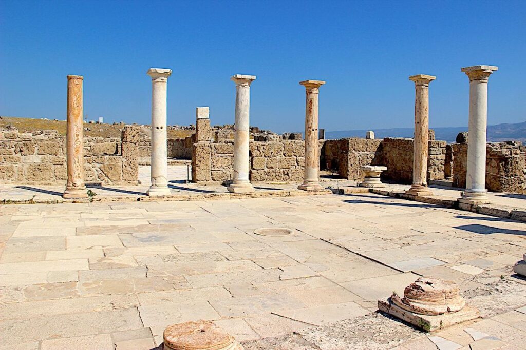
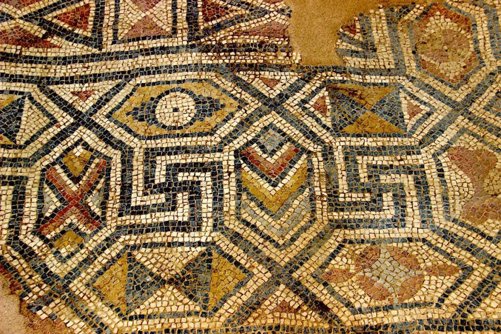
On the northern side of Temple A is the recently restored Laodicean Church, now a main tourist attraction of Laodicea. Discovered and completely unearthed in 2010, it is one of the oldest Christian churches in the world, dating back to the reign of Constantine the Great (272 -337 A.D. Emporer 306 – 337 A.D.). Severely damaged by an earthquake in 494 A.D., it was rebuilt and finally destroyed in an earthquake circa 602 – 610 A.D. Now covered with a protective roof, a partly transparent platform has been prepared for the visitors to view below. The three-aisled basilica has eleven semicircular apses, two entrances, and a floor decorated with many mosaics. The church walls were decorated with frescoes and marble slabs.
The ruins of the North Basilica, built in the 5th century A.D., and an earlier Corinthian Temple are between the West and North Theatres, on flat ground. Agricultural activities have severely damaged both buildings, with numerous scattered fragments of the marble blocks. The church was built from travertine blocks, on the plan of a three-aisled basilica, after the earthquake of 494 A.D. at the end of the 5th century and served the city’s residents to the 7th century. The temple’s construction was financed by a leading family of Laodicea, probably in honour of an emperor. Some columns have inscriptions of the Roman period, from the 1st and the 2nd centuries A.D.
Stadium
In the western part of Laodicea are the remains of an ancient Stadium, the largest stadium in ancient Anatolia (UNESCO World Heritage List). Oriented along an east-west axis, the stadium was built into the slope of a hill. This structure had a length of 285 meters, a width of 70 meters, and could accommodate up to 25,000 spectators. The stadium was built in 79 A.D. and was dedicated to Emperor Vespasian (9 – 79 A.D. Emporer 69 – 79 A.D.) and proconsul Marcus Ulpius Traianus, the father of the future Emperor Trajan.
Residences
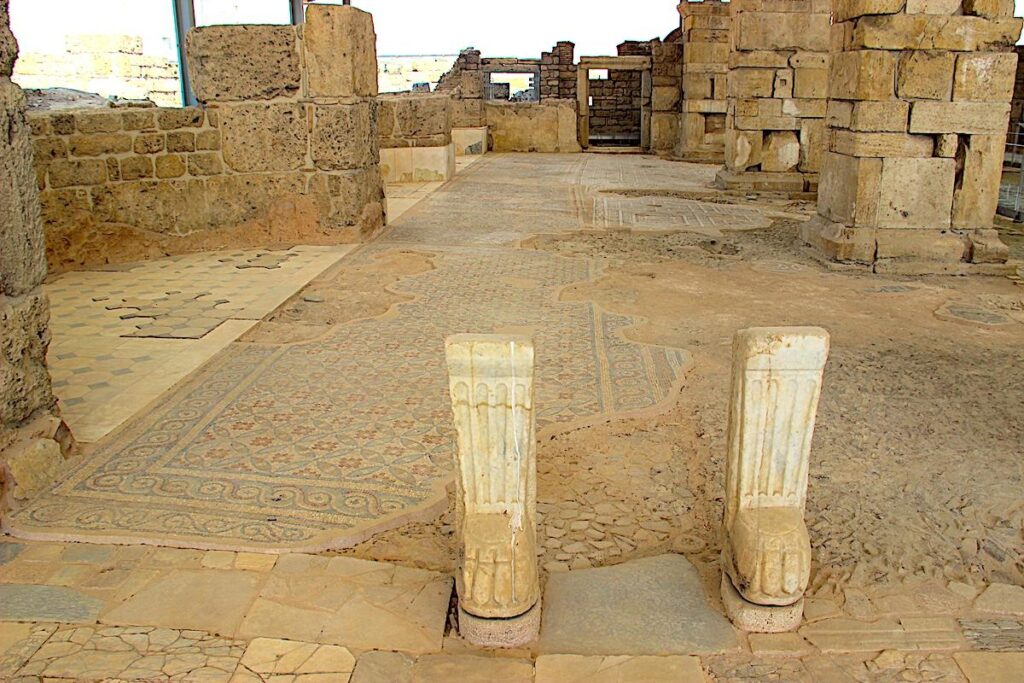
House A is in a side alley leading north from Syria Street. The building comprises an inner courtyard and interconnecting rooms with three houses and shops. Fresco remains observed on the walls, indicating the building was used as a house in the 3rd and 4th centuries A.D. However, storage jars, discharge hall, and brick flooring indicate alterations which transformed the building into a workshop in the 5th and 6th centuries A.D. The complex has sitting rooms with pools designed for drinking wine accessed behind the shop at the north entrance, wells for cooling the wine and storerooms behind.
Excavations such as balances, weights, and coins indicate that the city was improved in trade. House A was built on 2,000 square metres, and excavations revealed 38 shop units, a peristyle courtyard, and two passageways belonging to three houses. The courtyard, ancient fountain, pool, oven, and other areas reflect the architectural plan and style typical of the Imperial Roman period civil dwelling. Architectural features and finds of coins, pottery, glass, bone, and metal show that House A was used from the 3rd century A.D. to the beginning of the 7th century A.D.
The building complex identified as Peristyle House with Church is located south of the North Theatre, and the last building is at the end of the northwest of Temple East Street, which connects to the theatre. After the 2010 and 2011 excavations, it is understood that the side facing the Temple East Street has a unique church for inhabitants of the house. There is a naos room with dimensions of 7.0 x 9.0 metres and two church vestibule rooms 8.0 x 3.5 metres and 8.5 by 4.0 metres. There is also a peristyle courtyard 16.0 x 17.0 metres covering the east side of the house and linked rooms which open to the courtyard.
Water Distribution
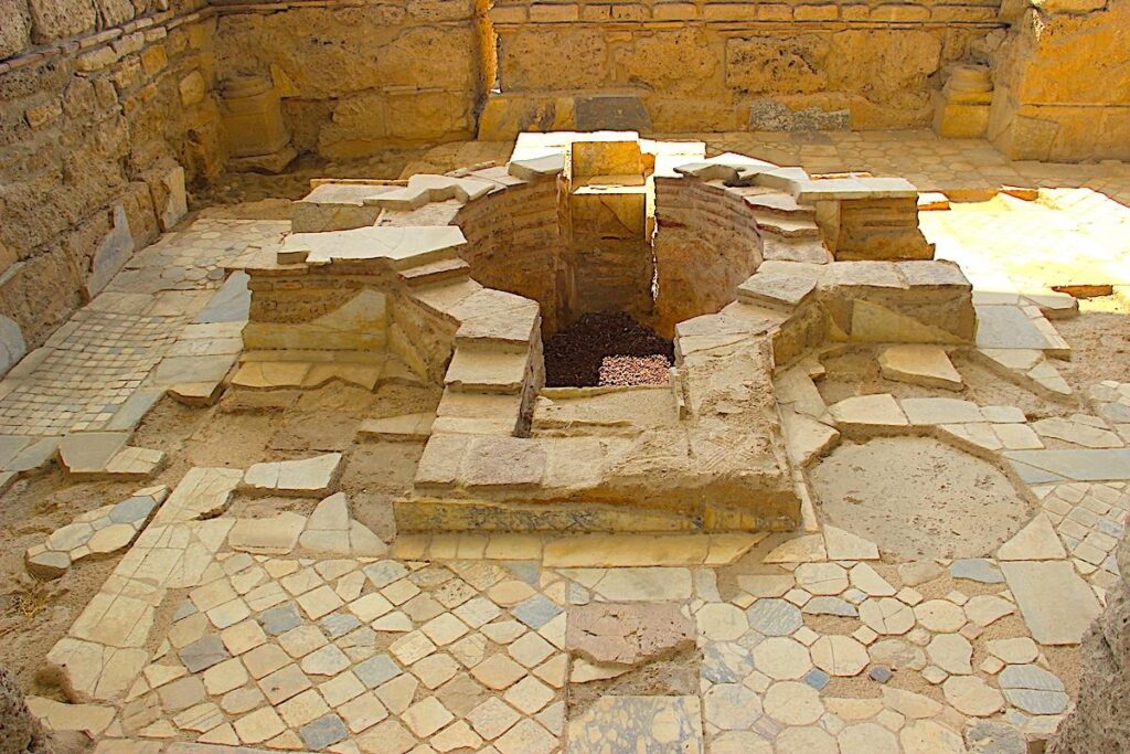
Located at the corner of a side alley leading north from Syria Street, the street water distribution centre was used when the city shrank in size following the earthquake of 494 A.D. Built with reused architectural elements; the centre is 2.1 x 2.4 metres with baked clay pipes supplying the water. A small pool and distributor lines show that the water was distributed from the pool in four directions via a triple strainer system.
Near the Stadium and South Baths is a castellum aquae (water castle – water distribution terminal) that supplied water to the nearby baths and onto the central water distribution terminal.
The water was imported to Laodicea via aqueducts, pipes, and syphons from a spring known today as Başpınar (Main) Spring, located about 8 km south of the city. Water from this source has a high mineral content, the deposits of which are visible in the water distribution terminals in Laodicea. Fragments of ancient pipes and an aqueduct can be found between the Başpınar spring and Laodicea in the village of Eskihisar.
Social Media
See also: LikeCesme – The Ancient Cities